The Heysen Trail
Scottish Country Dance Instruction
The Heysen Trail A 32 bar strathspey for four couples, danced in a longwise set. Lily Davison 19891- 8 All set and dance halfway round the set clockwise, then set again.
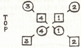
9-12 1st and 4th couples cross over giving right hand, then cast into the centre of the dance facing diagonally across the set in front of the corners. 2nd couple step up, 3rd couple step down (see Fig. 1).
13-16 All set facing diagonally to the centre, then 1st and 4th couples dance right hands across halfway around while the corners dance on one place to their right, i.e. anticlockwise.
17-20 All repeat the last four bars.
21-24 1st and 4th couples turn their corner persons with left hand, then 1st and 4th ladies, 1st and 4th men pass left shoulder on the last bar to return to their own sides in the order 2,1,4,3.
(4th lady turns 2nd lady, 1st lady turns 3rd lady, 4th man turns 2nd man, 1st man turns 3rd man.)
25-32 Reels of four on the side, passing right shoulder to begin. (2nd couple face 1st couple, 4th couple face 3rd to begin the reels).
Repeat from new positions.
(Dance crib compiled by the deviser, Lily Davison, 1989)
The Heysen Trail Figure 1
Dance Information
The HEYSEN TRAIL is a 2000 kilometre walking trail from Cape Jervis in the south to Mount Babbage in the north of South Australia, along the spine of the Mount Lofty and the Flinders Ranges. The trail is named after the well known painter Sir Hans Heysen who, although not a walker, had strong associations with both the Mount Lofty area and the Flinders Ranges.Recommended tunes: As for "The Logan Brig" on "Dance to Bobby Crowe's Band" (Thistle records (B.S.LP.67).
(Dance information by the deviser, Lily Davison, 1989)
The Heysen Trail is a long-distance walking route in South Australia, extending approximately 1,200 kilometres from Cape Jervis on the Fleurieu Peninsula to Parachilna Gorge in the Flinders Ranges.
It passes through various landscapes, including coastal areas, the Adelaide Hills, Barossa Valley, and arid regions beyond Goyder's Line. The trail traverses national parks, conservation areas, and private properties, offering a range of natural environments.
The concept of the trail was proposed in 1969 by Warren Bonython. The first section opened in 1976 within Cleland Conservation Park. Under the guidance of Terry Lavender, the trail was progressively developed and completed in 1993.
The trail is named after Sir Hans Heysen, a German-born Australian artist known for his depictions of the Australian bush. His former residence, The Cedars, is located near the trail in Hahndorf.
Due to bushfire risk, sections of the trail are closed annually from December through April. Most hikers complete the trail in segments, although a full traverse typically takes about 60 days.
Facilities along the trail include campsites, huts, and water tanks. However, hikers are advised to carry sufficient water, as tank levels can vary.
The Friends of the Heysen Trail, a volunteer organisation established in 1986, assists in maintaining the trail and promoting bushwalking activities.
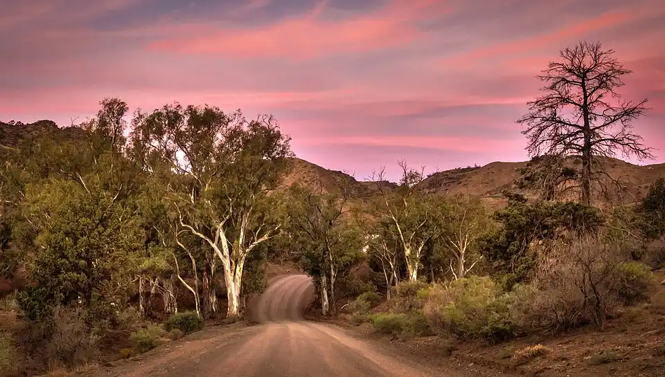
Heysen Trail, Parachilna Gorge, The Northern Trailhead
Published in The Thistle And Vine, Copyright 2025, reproduced here with the kind permission of the president of RSCDS Adelaide And Districts Branch, Australia, 2025. All rights reserved.
Published in The Thistle And Vine Original, Copyright 1989, reproduced here with the kind permission of the president of RSCDS Adelaide And Districts Branch, Australia, 2025. All rights reserved.
This page uses content under the Creative Commons Attribution-ShareAlike 4.0 International License, along with original copyrighted content and excerpts from Wikipedia and other sources.
Text from this original Heysen Trail article on Wikipedia.
Image copyright Jacqui Barker, CC BY 2.0, via Wikimedia Commons.
Back to the top of this Scottish Country Dancing Instructions 'The Heysen Trail' page